Ngoc Hoi Bridge, with a $470M investment, will link Hanoi and Hung Yen, enhancing traffic and unlocking southern development potential.
Table of Contents
Hanoi authorities have officially unveiled the location and detailed planning for Ngoc Hoi Bridge, a strategic infrastructure project connecting the capital with Hung Yen Province. With an estimated investment of VND 11.8 trillion (approximately USD 470 million), the project aims to improve inter-regional traffic and boost southern Hanoi’s development.
Special-grade bridge with regional impact
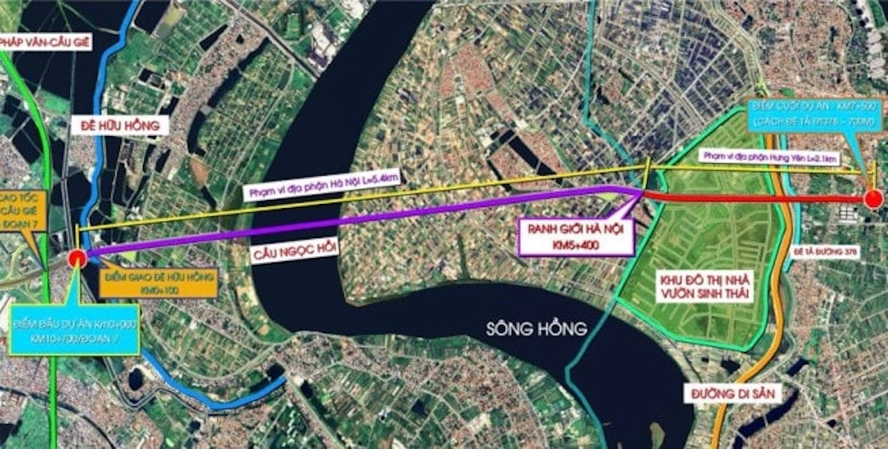
According to the plan presented by the Hanoi Institute of Planning and Architecture and the city’s Management Board for Transport Construction Investment Projects, Ngoc Hoi Bridge is classified as a special-grade infrastructure project. It will begin at the intersection with Ring Road 3.5 (from Phuc La – Van Phu to Phap Van – Cau Gie Expressway) and end at Kim Duc Commune in Gia Lam District, bordering Hung Yen Province.
The total planned length is 5.2 km, of which 5.4 km will lie within Hanoi and 2.1 km in Hung Yen. The bridge will cross the Red River, aligning with the Ring Road 3.5 corridor – a critical belt road shaping Hanoi’s urban expansion.
Modern design and large-scale layout
The bridge will feature:
Cross-section width: 33 meters
6 motor vehicle lanes
Mixed-traffic lanes
Pedestrian walkways
A key segment, from Chu Cu Van Mausoleum to the city boundary, will expand to 60.75 meters, incorporating a central viaduct, service roads, and sidewalks.
Start and end points strategically placed
Starting point: Located in Thanh Tri District, ~360 meters from the Huu Hong dike, linked to the planned Ring Road 3.5 segment.
Ending point: Situated in Van Giang District, Hung Yen, ~700 meters from the Ta Hong dike and near the Hanoi–Hai Phong Expressway.
This positioning allows seamless connection to key urban projects such as Ecopark, Dream City, and Dai An, forming a new growth corridor southeast of Hanoi.
Unlocking growth in southern Hanoi and beyond
The Hanoi People’s Committee emphasized that Ngoc Hoi Bridge will enhance transportation efficiency, reduce traffic pressure on current crossings, and unlock economic and social growth in the southern region of Hanoi and neighboring provinces including Hung Yen, Ha Nam, and Bac Ninh.
In particular, real estate and industrial zones along the corridor are expected to benefit significantly, thanks to the improved infrastructure and increased accessibility.
Part of a larger Red River bridge network
At present, eight bridges span the Red River in Hanoi: Thang Long, Chuong Duong, Vinh Tuy, Thanh Tri, Nhat Tan, Long Bien, Vinh Thinh, and Viet Tri–Ba Vi.
Under Hanoi’s transportation master plan to 2030, with a vision to 2050, ten more Red River bridges are planned:
Tu Lien
Tran Hung Dao
Van Phuc
Hong Ha
Me So (Ring Road 4)
New Thang Long (Ring Road 3)
Vinh Tuy (Phase 2)
Thuong Cat
Ngoc Hoi (Ring Road 3.5)
Phu Xuyen
These projects aim to complete the city’s ring road system and facilitate long-term regional integration.
With its strategic location, modern design, and multi-phase execution, Ngoc Hoi Bridge is a cornerstone project in Hanoi’s infrastructure roadmap. Backed by a VND 11.8 trillion budget and strong political will, it is set to become a key driver of urban and economic transformation across the southern Red River corridor.
Ready to invest smartly in Vietnam’s real estate market? 📩 Reach out to Realtique for insider insights, expert guidance, and exclusive property deals tailored for international investors.


