
Ho Chi Minh City Urban Planning to 2030: What Foreign Investors Should Know (2026)
Where a city plans to grow is where its property values migrate. Ho Chi Minh City is in the middle of the most consequential infrastructure build-out in its history — a new financial centre, a ring-road network, a new international airport, and an expanding metro — and together these projects are redrawing the map of where demand and value will concentrate by 2030. For a foreign investor, reading that plan is the difference between buying into growth and buying into stagnation.
This guide walks through the big moves — Thu Thiem, the ring roads, Long Thanh airport, the metro network and the riverfront — and what each means for where to position.
Table of Contents

Thu Thiem — the new central business district
The ring roads — Rings 2, 3 and 4
Long Thanh International Airport
The metro network
The riverfront and green plans
The eastward and southward shift
What it means for prices
Which areas to watch
The risks to weigh
How foreign buyers should position
Who should care about the 2030 plan
A note on timelines and patience
The eligibility rule applies everywhere
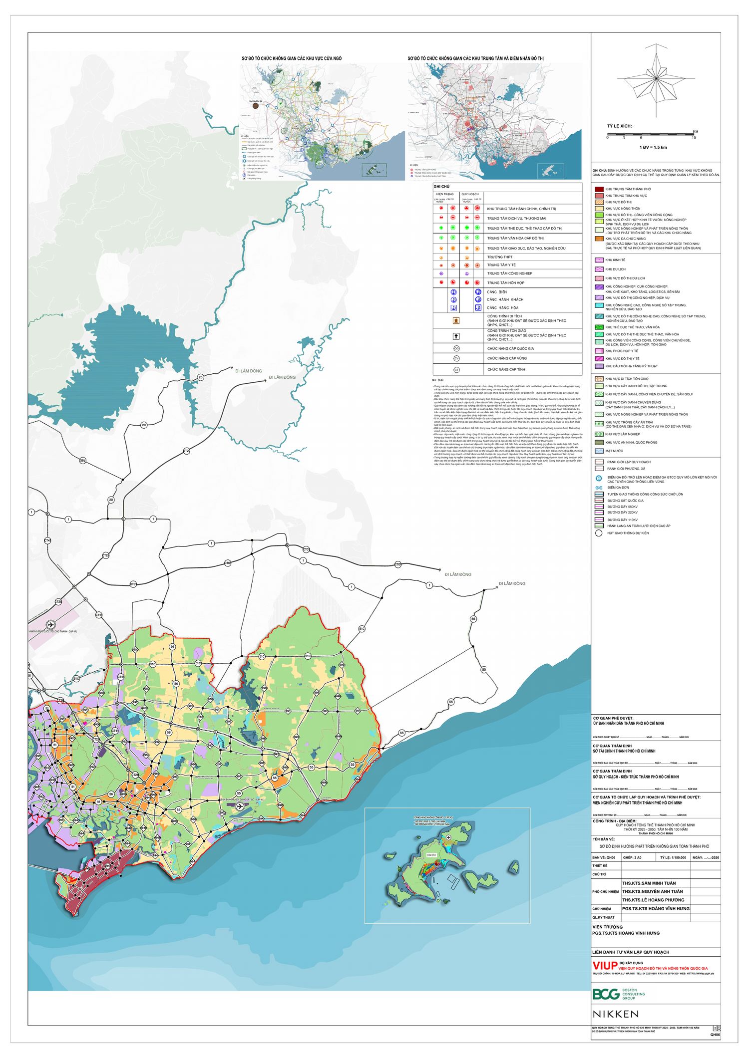
The 2025–2050 Master Plan: A Polycentric Mega-City After the Merger
The 2030 moves above sit inside a much larger new blueprint: the Ho Chi Minh City Master Plan for 2025–2050, with a 100-year vision. Crucially, this is the first strategic plan for an enlarged city after the 2025 administrative merger, which folded neighbouring Binh Duong and Ba Ria–Vung Tau into Ho Chi Minh City. The new city spans roughly 6,772 km² across 168 administrative units (including the Con Dao special zone), bordered by Dong Nai and Lam Dong to the east, Tay Ninh and Dong Thap to the west, and the sea to the south.
The core idea is to convert what could have been a “mechanical merger” into a deliberately organised polycentric, multi-hub structure the plan calls a “Polycentric Hyper City”. Instead of one dominant downtown, growth is distributed across a network of poles and centres linked by fast infrastructure — a model designed to compete at the Asia-Pacific scale while spreading jobs, population and investment more evenly.
The Five Growth Poles
The plan defines five growth poles, each with a distinct economic role. For an investor, these are the clearest signal of where infrastructure, jobs and housing demand will concentrate over the next two decades:
- International core pole — Saigon, Cho Lon, Thu Thiem and both banks of the Saigon River: the international finance, governance and high-value-services centre, with priority on urban regeneration and the riverfront.
- Eastern innovation pole — Thu Duc, Di An, Thuan An and the Long Thanh airport link: a Southeast Asian innovation valley for AI, semiconductors, R&D, universities, start-ups and high-tech manufacturing.
- Northern industry–logistics pole — Binh Duong, Thu Dau Mot, Ben Cat, Bau Bang: high-tech manufacturing and smart logistics, evolving from single-purpose industrial parks into integrated industry–service–urban ecosystems.
- Southern seaport–free-trade–energy pole — Can Gio, Cai Mep, Thi Vai, Phu My, Long Son: an international trade gateway anchored by a deep-water transshipment port, a free-trade zone, global logistics and energy.
- Coastal tourism pole — Vung Tau, Long Hai, Ho Tram: a world-class coastal belt for resort tourism, marine economy, wellness and the night-time economy.
Zones, Strategic Linkages and Transit-Oriented Development
On top of the five poles, the plan divides the city into ten development zones — among them the financial-and-heritage core, the eastern innovation zone, the western–south-western gateway to the Mekong Delta, the Binh Duong industry-and-services zone, the Can Gio marine-ecology zone, the Vung Tau–Long Hai–Ho Tram coastal-tourism zone and the Con Dao special zone.
These are stitched together by five strategic linkage systems (north–south, east–west, a multimodal industry–logistics corridor, a multi-layered urban-infrastructure network and a “green–blue” ecological system), and by a strong commitment to transit-oriented development (TOD) and the use of underground space. For property buyers, TOD is the key phrase: land around future metro stations and major transport interchanges is where the plan concentrates density and value uplift.
The 100-Year Vision
The long-range vision positions Ho Chi Minh City as a global, smart and modern city on par with the world’s leading metropolises — an internationally influential hub for finance, trade, logistics, science, technology and innovation, and a magnet for talent, enterprise, capital and technology. The guiding principle throughout is people-centred, green and climate-resilient growth, rather than growth by density alone.
What It Means for Foreign Buyers
For a foreign investor, the polycentric structure is a practical map. It reinforces the eastward shift toward Thu Duc (the innovation pole), where premium housing is already active, while opening two longer-horizon frontiers to the south — the Can Gio seaport-and-eco-city axis and the Vung Tau coastal-tourism belt — and confirming Binh Duong’s role as an integrated industry-and-housing hub. A sensible reading is to anchor in the mature eastern and core markets while watching the southern frontiers for early-stage value.
As always, treat a master plan as direction and probability, not a delivery guarantee: infrastructure timelines slip, and patience is part of the strategy. And wherever the plan points, the ownership framework is constant — for the rules that apply to every purchase, see our Foreign Buyer Guide.
Frequently asked questions
How is Ho Chi Minh City’s planning changing the property map?
Major projects — the Thu Thiem CBD, the ring roads, Long Thanh airport and the expanding metro — are shifting growth east and south-east, re-rating land along those corridors while the historic core keeps its scarcity premium.
What is the biggest planning project affecting property values?
Thu Thiem, the new financial centre across the river from District 1, together with the metro and the ring-road network, is redrawing where central demand concentrates. Long Thanh airport reinforces the eastern, south-eastern shift.
Should I buy based on future infrastructure?
Weight decisions toward infrastructure that is operating or firmly funded, and treat distant, unbuilt projects as upside rather than the basis of a purchase. Favour well-capitalised developers who can deliver regardless of the wider timeline.
Which areas benefit most from the 2030 plan?
Thu Thiem, the An Phu–Nam Rach Chiec corridor, metro-served Thao Dien and Binh Thanh, and the eastern townships along the airport axis — each covered in its own guide in this series.
Related guides
New to buying here? Start with Can foreigners buy property in Vietnam? and the step-by-step buying process.

KC and the Realtique team help international buyers pick the right Ho Chi Minh City neighbourhood — matching lifestyle, budget, rental yield and foreign-ownership eligibility, then handling the purchase end to end.
Want to position for Ho Chi Minh City’s 2030 growth?
Realtique guides international buyers end to end — area selection, eligibility, quota, due diligence, legal transfer and the pink book.
Start today. Leave your name and email — a Realtique specialist will reach out. Or email [email protected].